|
|
Council Agenda - City of BurbankTuesday, November 9, 2004Agenda Item - 6 |
|
|
Council Agenda - City of BurbankTuesday, November 9, 2004Agenda Item - 6 |
|
|
||||||||||||||||||||||||||||||||||||||||||||||||||||||||||||||||||||||||||||||||||||||||||||||||||||||||
|
|
||||||||||||||||||||||||||||||||||||||||||||||||||||||||||||||||||||||||||||||||||||||||||||||||||||||||
|
PURPOSE
The Land Use and Mobility Elements of the City�s General Plan are concurrently scheduled for completion in April 2005. This report presents the proposed changes to the Multi-Family Residential Land Use Categories of the Land Use Element including new density classifications. Staff requests that Council discuss the proposed density classifications and provide appropriate direction.
BACKGROUND:
On November 18, 2003 the City Council discussed concerns raised by residents and City Council members regarding the amount of multifamily housing development taking place across the City, and especially in the area east of downtown; City Council directed staff to return with several options for adopting an Interim Development Control Ordinance (IDCO) that would temporarily restrict the development of certain types of multiple family residential development. On January 13, 2004, the City Council held a public hearing to consider adoption of such an IDCO. The City Council decided not to adopt the proposed IDCO and instead continued the public hearing and directed staff to return with options for adopting an ordinance to modify the existing Development Review (DR) process by adding required compatibility findings. On February 10, 2004 staff brought an emergency ordinance requiring compatibility findings for all new multiple family development to the City Council and it was adopted that night. The City Council then directed staff to proceed with a study of densities and development standards.
ANALYSIS
Residential land use densities play an important role in defining the character and quality of life in Burbank. Over the past 2 years, there has been increasing concern among residents and the City Council that too much new multiple family residential construction is going on, too fast, and that the effect is a change in the character of certain neighborhoods as well as increasing impacts resulting from the addition of more dwellings and residents in a limited area of land. Although ongoing multifamily development is a citywide issue, the specific area that prompted the Council�s concerns is the area immediately east of downtown, bounded roughly by Glenoaks Blvd, Harvard Road, Kenneth Road, and the City boundary with Glendale. This area has been the center of the majority of multifamily development for the past several years because it is the largest concentration of multifamily zoning in the City and because there are many opportunities for development in the area.
There has been ongoing discussion as to whether the perceived change of character and many of the impacts are the result of design flaws or the density of the new development. The answer is that the changes and impacts are a result of both density and design factors. Burbank�s existing residential densities are higher than most of the neighboring communities (see Exhibit A) and reducing them could have a positive effect on the type of development that will occur in the community. By making changes in the design of some of the new developments, the ambiance of Burbank�s multiple family residential neighborhoods would be further improved. Making changes to either density or design alone, without making complimentary changes to the other, may not have the desired result of improving the quality of multifamily development while minimizing its impacts on the community and neighborhood character; it is important to look at both aspects of development together.
The issue of residential densities is a critical component of the 2005 General Plan Land Use Element (LUE) update. In an effort to address this issue, staff is working with consultants � EIP Associates and Keyser Marston Associates (KMA) � to decide on appropriate, financially sustainable and realistic densities for the updated LUE. This report presents the background, issues and proposed changes to residential distribution and multiple family densities that staff proposes to include in the 2005 update of the Land Use Element in order to address the concerns about new multiple family residential development.
Burbank�s residents perceive Burbank as a �small town�, with the friendly small town character and the physical ambiance of a small town. Residents feel that this small town feeling is threatened with the increasing intensification of the multiple family residential areas. The increasing intensification is not the result of up-zoning or increased densities, but rather the ongoing building out of existing densities that have been in place since the 1960�s. As more and more lots in these traditional multiple family areas recycle to the higher allowed density, the effects on character and impacts of density and design are more noticeable. Many multifamily properties in the City, although designated by the General Plan and zoned for higher density, have remained developed with single family homes, duplexes, and similar low density development. As these properties recycle, the character of the neighborhood changes from low density and low intensity to higher densities characterized by much larger structures. This change in character has been anticipated as an inevitable event by the General Plan and Zoning Ordinance for decades. However, the rapid pace of development over the last few years has allowed the community to fully realize the impacts of the level and type of development allowed in the City.
Defining Density Classifications
Before discussing proposed density changes it is important to explain density classifications both in the General Plan Land Use Element and the Zoning Ordinance. It is important to understand the difference between General Plan Land Use allocations and Zoning, and how they work together to guide the City�s future development. The General Plan Land Use Plan indicates the ultimate pattern of land uses and intensity of development envisioned for the City in the year 2025. The City�s zoning implements the land use designations and policies.
The existing 1988 General Plan Land Use Plan contains four residential land use districts, one for Single Family and three for Multiple Family; five residential zones implement these residential land use districts. The following table shows how the current land use and zoning correspond:
Table 1 Existing General Plan Land Use and Zoning Categories
* du/ac = dwelling units per acre sf/la = dwelling units per square foot of lot area ** Property in the Multiple Family High Density category is given an R-4 zoning since all density over R-4 requires City Council discretionary approval. NOTE: Multi-family Medium and Low densities can be exceeded by means of the Planned Development process.
Generally, the zoning classification on the zoning map corresponds with the classification on the Land Use Element map. In other words, an area zoned R-3 typically is identified as Multiple Family Low Density on the Land Use Element map, whereas R-4 typically is identified as Multiple Family Medium Density in the Land Use Element.
How Much Capacity Does Burbank Need?
The amount of residential development allowed by density limits and development standards in the Land Use Element and the Zoning Ordinance determines the City�s residential capacity � the total number of residential units that can be built. There are several reasons that Burbank needs room to grow and change. �Growth� and �change� are words that typically cause concern for cities, and Burbank is no exception. Burbank is a community which values its small town character and unique qualities. But some growth and change is necessary to preserve the quality of life in Burbank, and respond to various needs in the community; this change and growth does not have to negatively affect the City�s unique character. Some reasons for some continued growth and change are explained below.
Burbank is a family town � a town of not only nuclear families, but of extended families. Burbank residents are proud of the multigenerational character of the population. In order to provide for Burbank residents as they age and need to downsize in housing, and for young residents to move out on their own and for young families to establish here in the community, it is necessary to provide not only more but a wider variety of housing options.
The single family paradigm of parents and children - long the norm in Burbank and Southern California in general � is no longer the predominate household type. Numerous demographic studies, tell us that the demographics of our society are changing along with household composition. There are an increased number of single parent households, more dual income households without children as well as increased instances of adult children living at home with their parents. With the changes in ethnic demographics in Burbank, there is an increase in multigenerational family units living together. These changes necessitate changes in the type of housing provided in the community if the various members of the Burbank community are to be accommodated.
Since at least the 1960s, Burbank has been a regional employment center, providing many more jobs than needed for Burbank�s working population and enjoying the economic benefits of a healthy large economic base. Beginning with Lockheed and related aerospace industries that benefited from locating in proximity to the airport, and transitioning in the 1980�s to motion picture and media related industries that benefit from concentrating in proximity to the studios long established in Burbank, the City provides about 100,000 job opportunities. This number is forecasted to increase as commerce and industry in the City grows over the next 20 years. Burbank continues to benefit financially from this large and healthy economic base and it is a policy of the Land Use Element, and a tenet of the City�s 10-Year Stratigic Plan, to foster and support our local businesses.
This large employment base generates additional housing needs. Businesses want to know that their employees and executives can find housing in the community. Employees that are
forced to live far from their place of employment contribute to traffic and air pollution resulting from long commutes.
Burbank has a responsibility to both its businesses and the employees of those businesses to provide housing opportunities if it wants to continue to enjoy the benefits of the strong economy.
Burbank population growth since 1950 has averaged about one half percent a year. This reflects the significant 6.5% drop in population from 1960 to 1980, and the turn around between 1980 and 1990 which saw a 10.5% increase in population. Population growth slowed somewhat to 7% during the decade from 1990 to 2000. From 1980 to 2004 the population grew by 24.6%, averaging about 1% per year.
Burbank�s housing stock has grown steadily over the years. Since 1960, Burbank�s housing stock has increased by an average of two thirds of a percent (0.66%) each year. Even during the two decades of population decline, from 1960 to 1980, residential construction proceeded at the same pace. Residential construction is cyclical, responding to economic and market factors that are outside of Burbank�s control. Looking at any one year, or even one decade, is deceptive with regard to overall development trends. In the 1980�s for example, Burbank�s housing stock grew by 11% - an average of about 1.1% annually. However, in the decade that followed, there was only a 4% growth in housing stock � an annual average of only 0.4%. The past four years (2001-2004) have shown an average growth rate of 0.65% per year.
The proposed Land Use Element update assumes a slight reduction in the rate of residential growth rates to reflect the reduction in residential densities and the gradual building out of residential land in the community. Growth is anticipated to average about 0.6% per year over the 20 year scope of this Land Use Plan � about 260 units per year. At this rate, Burbank could expect to add about 5,160 new residential units, bringing the current 43,100 units up to a total of about 48,265 units in 2025.
The following table shows the rate of residential growth over the past 5 � years. One can see that the average of the five year period between 1999 and 2003 is less than 200 units per year, which is less than the 0.6% growth scenario assumed for the 20 year scope of the 2005 Land Use Element update.
Table 2 Residential Building Permits Issued 1999 � September 2004
This table also illustrates the cyclical nature of the housing market both with regard to the amount of new development and the type of development. Recent economic factors have encouraged an upsurge in for-sale housing � condominiums � as compared to rental housing that has been the predominant trend for the past several years.
As the City builds-out, and there is less available land and fewer opportunities for new residential development, it is reasonable to assume that the rate of residential development and population growth may slow. It is generally accepted practice to include some excess capacity in the Land Use Element � over and beyond that needed to respond to the likely growth trends in the community. For example, if the City anticipates adding 5,160 new units over the 20 year span of this Plan, the Plan should include capacity for more than this number to compensate for the numerous underutilized properties that may not be for sale or for which there is no incentive for recycling, and the increased difficulty in acquiring and assembling property as the community builds-out.
4. State mandate to provide for fair share of regional housing growth and needs.
The State of California requires every City, as part of its mandated General Plan Housing Element, to provide adequate sites and capacity for meeting its fair share of the future growth in the region. This requirement is carefully mandated in State Planning Law and the City is required, every five years, to produce a Housing Element that must be approved by the State Department of Housing and Community Development (HCD). The Housing Element must show that the City has the capacity and available sites to accommodate a given amount of new housing, that it has programs in place to encourage the production of new housing and ensure that a given proportion of that new housing is affordable to lower income households, and that there are no City constraints to the production of new housing. The amount of new housing the City must accommodate is called its Regional Housing Needs Assessment (RHNA) and is a number allocated to each City according to State Law. The City is not required to build this amount of new housing, or cause it to be built, but in order for the State to approve the Housing Element, the City does have to have programs to encourage new construction, the capacity and appropriate densities to allow for the requisite amount of housing and address any constraints to new housing production. The State HCD looks carefully at a City�s residential land use capacity when evaluating its ability to meet its local housing needs and its allocated share of the regional growth.
The past two Housing Element cycles had RHNA allocations of 2,970 and 2,242 new units for each five-year period. It is reasonable to assume that future RHNA allocations will be in this range. Burbank�s next Housing Element update, which will have a new RHNA number to be addressed in the Element, is scheduled for adoption in 2006. It will stipulate the number of housing units that must be accommodated and facilitated through the year 2011. Recent conversations with the State HCD indicate that the RHNA allocation for the 2006 housing element will be higher than that in previous years. The Land Use Element should address and provide for the housing needs of the community over the 20 year time span of the plan, from 2005 to 2025.
Discussions are underway at the State level as to how to amend existing housing element law to ensure that cities provide for their fair share of the anticipated growth in the southern California region. Increasingly stringent proposals are being discussed in Sacramento which include requiring cities to show sufficient zoning capacity for anticipated growth over the next 10 years or more.
Cities are expected to plan for growth consistent with regional growth forecasts. The most recent regional growth forecasting document � the 2004 Regional Transportation Plan � shows Burbank with an average annual growth rate of 0.8% � 0.9% over the 20 year horizon of the updated Land Use Element. This is a higher rate of growth than anticipated by the Land Use Element update and, as will be explained later in this report, slightly higher than can realistically be accommodated by the proposed residential densities.
Multiple Family Density Proposals for the 2005 Land Use Element Update
Following the adoption of the 1988 Land Use Element, and the boom in multiple family construction in the second half of the 1980�s, Measure One was passed to limit the City�s residential capacity to that allowed in the adopted Land Use Element. In addition, several zone text amendments were adopted to reduce the impacts of multiple family residential developments adjacent and in proximity to Single Family areas. This is the first time, however, that the character of the multiple family residential areas themselves has been studied in terms of density and design, and mitigation sought.
In light of the information gleaned from the density analyses and studies, the 2005 Land Use Element update proposes to address the multiple family density concerns by adjusting multiple family land use categories and reducing densities. In order to be able to reduce residential densities and still meet the housing needs of the community, it has been necessary to compensate for the reduced housing capacity by allowing for and encouraging new residential units elsewhere, in a location and manner that will not have significant impacts on adjacent uses or the community as a whole.
The multiple family residential changes proposed for the 2005 Land Use Element Update include the following:
These major changes to the Land Use Element are discussed in more detail below.
1. Reduced Densities In order to assure that the reduced densities proposed are feasible for development in the Burbank real estate market, an economic analysis has been completed by Keyser Marston Associates (KMA). This economic analysis determined the supportable land value or what a developer could afford to pay for the site to build the project and expect a reasonable rate of return on their investment. The results of the feasibility analysis by KMA were used as a basis to establish appropriate residential densities for continued infill and new multiple family residential developments.
Table 3 below shows the new range of residential land use categories proposed for the 2005 Land Use Element Update and how they compare to the existing land use categories. The table also shows which zones will implement the new land use districts. One change that is immediately obvious in the table is that the proposed Element designates 5 residential land use districts instead of the 4 used in the existing 1988 Element. A new Compact Single Family density has been added to accommodate an expanded R-2 density and will include new provisions for Compact Single Family development. Currently the R2 zoning density is allowed in and considered part of the traditional single family neighborhoods; in the proposed 2005 Land Use Element Update, this lowest multiple family density will be a separate land use category. This new category will be discussed in detail at the upcoming discussion with City Council on November 23.
Table 3 Proposed New Land Use Categories and Applicable Zones Compared to Existing Categories and Zones
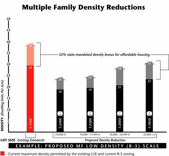
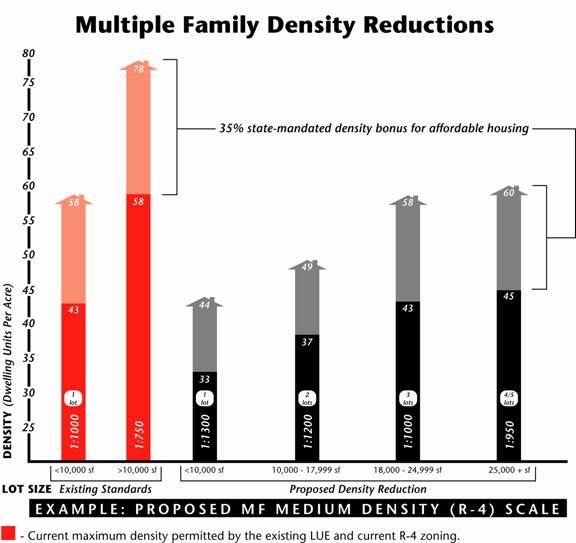
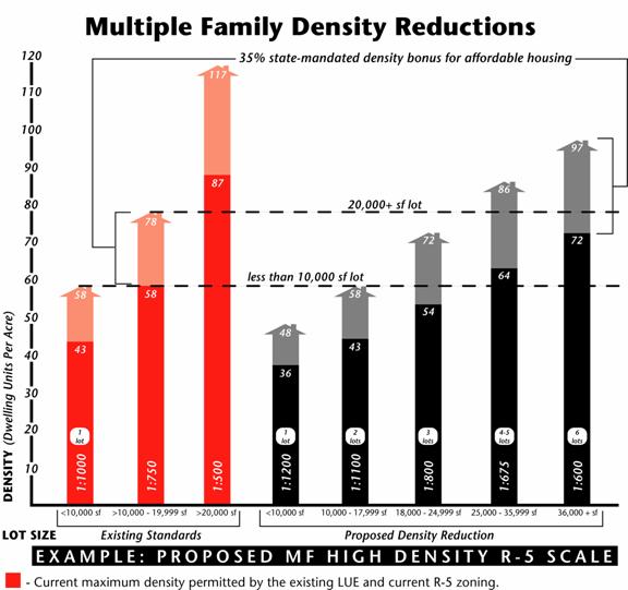
The graphs on the following page show the proposed density for the Low, Medium and High multiple family residential land use categories and how allowed density increases as lot size increases; larger lots are considered to be more suitable for higher densities in terms of design and development standards. Current state law requires cities to grant up to a 25% density bonus to new residential developments which provide a proscribed proportion of units affordable to low and very low income households. Effective January 1, 2005 however, a new state density bonus law goes into effect which will mandate a maximum density bonus of up to 35%. The proposed density scale is structured in such a way as to ensure that even with the state mandated affordable housing density bonus, densities will not exceed what is currently allowed without the bonus.
LOW DENSITY MULTIPLE FAMILY
The densities in the Low Density Multifamily residential category, implemented by the R-3 zone, would be reduced by about 37%, depending on lot size, as can be seen above. Currently, a 7,500 square foot lot can build 5 units, whereas the proposed reduction would allow 3 units � a 28% reduction in density. On a larger lot, such as two lots assembled into a 15,000 square foot parcel, the current R3 density would allow 10 units to be built, whereas the proposed density scale would allow only 6 units � a 40% reduction in density. Even on the largest parcels, over 25,000 square feet, the reduction would result in 19% fewer units. This will be the largest geographical multiple family land use category in the proposed 2005 Land Use Element update, and a significant reduction in the permitted density will have a notable effect on the residential capacity in the City.
MEDIUM DENSITY MULTIPLE FAMILY
The permitted densities in the Medium Density Multiple Family residential land use category, implemented by R-4 zoning, would be reduced by about 22%. Currently, a 7,500 square foot lot can build 7 units, whereas the proposed reduction would allow 5 units � a 28% reduction in density. On a larger lot, such as two lots assembled into a 15,000 square foot parcel, the current R4 density would allow 20 units to be built, whereas the proposed density scale would allow only 13 units � a 33% reduction in density. Even the largest parcels, over 25,000 square feet, would result in 19% fewer units.
HIGH DENSITY MULTIPLE FAMILY
The High Density land use category, implemented my means of the Planned Development process or the R5 zone, would be reduced about 17% - 37%, depending on lot size. Currently, High Density development has the same densities at the Medium Density category (R-4) for lots less than 20,000 square feet. Under existing land use and zoning, an assemblage of 4 lots equaling 24,000 square feet could built 48 units, whereas the proposed density would allow a maximum of 35 units � a 27% reduction in the number of units that can be built.
2. Geographic Distribution of the Multiple Family Residential Categories Changing the geographic distribution of the multiple family residential categories, in and of itself, has the effect of lowering densities in certain critical areas, such as adjacent to single family zones. In the proposed 2005 Land Use Element Update, residential land use distribution is adjusted to change about 250 acres of the existing Medium Density designated multiple family land (comparable to the current R-4 zone), to a lower density land use category (comparable to the R-3 zone) in order to reduce potential impacts on the adjacent single family zone. This reduction affects about half of all land currently designated for Medium Density Multiple Family land use. Most of the land area removed from the Medium Density Multiple Family land use category (R-4) is in close proximity to R-1 single family neighborhoods. Special development standards adopted to protect the R-1 single family neighborhoods from impacts of adjacent multiple family development, limit the height and lot coverage allowed for multiple family residential developments within 500 feet of the single family zone. These restrictions have effectively limited the development on these properties to that equivalent to the Low Density Multiple Family category � R-3. Therefore, in light of existing zoning restrictions, the actual impact of the change in land use category for properties adjacent R-1 is negligible.
Similarly, 40 acres of land now designated as Low Density Multiple Family (comparable to the current R-3 zone), the development of which could possibly have a negative impact on neighborhood character, would be changed to a new lower density residential category (comparable to an R-2 zone); this represents about 20% of land currently designated for Low Density Multiple Family use. The areas in which the land use designation would be changed to a less dense category are shown on the map below.
Map 1 PROPOSED AREAS WHERE RESIDENTIAL DENSITY CATEGORY WILL BE LOWERED
The geographic distribution of the various land uses has been discussed in the Land Use Element Update advisory committee and shared with the public at 5 community meetings this past May and June. These land use issues will continue to be discussed and refined t hroughout the adoption process.
3. Residential Development in Commercial Areas. The addition of new mixed use districts is intended to encourage the development of new residential development in appropriate commercial areas; this is an important change proposed for the 2005 Land Use Element Update. The proposed Plan will allow both residential and commercial land use development along certain commercial corridors and in the Downtown area. Residential use in these areas is not only allowed but encouraged. Whereas residential uses would be permitted only above the ground floor in certain commercial areas, in order to create an interesting walking environment, the commercial corridors would permit all residential projects. Currently the general plan and zoning allow for residential development above the ground floor with a CUP, though this type of development has proven over the past several years not to be economically viable on the commercial corridors. The changes proposed in the 2005 Land Use Element update are intended to provide additional residential options in proximity to retail and service establishments and public transportation as well as increasing safety in the mixed use centers with 24-hour occupancy.
The residential development that can be added in these commercial areas will augment the residential capacity of the Land Use Element, and help offset the significant capacity reduction resulting from the changes to residential land use distribution and density reductions. Staff has estimated that about 3,700 additional residential units (1,500 currently exist) could be accommodated in the commercial mixed use areas over the 20 year time frame of this plan; this estimate is based on assumptions regarding how much of the development in these areas will be residential, and at what densities, and how much will be recycled commercial development. Many of these units already exist in the Downtown area. All estimates of the amount of residential development that will occur in commercial areas are based on the proposed 2005 Land Use Element update land use categories and distribution. This includes areas such as the corner of Buena Vista Street and Empire Avenue, which is proposed to changed from the current industrial designation to a new mixed use commercial designation which would allow for residential development. With the addition of the 5,200 unit capacity in commercial areas, the impact of reduced densities on the overall residential capacity is reduced and the City is better able to meet the housing needs in the community and the state mandated requirements.
Commercial areas that allow residential development are of two types, those in which residential densities are limited by shallow lots and adjacency to single family residential areas, such as along major corridors like Burbank and Magnolia Boulevards, and those commercial areas that are not adjacent to single family residential areas and which have larger lot sizes that allow for a creative mix of residential and commercial uses. Whereas some residential development was conditionally allowed in commercial zones in the past, the increase in retail commercial establishments in the City since 1988 makes the development of residential instead of commercial development more attractive financially, especially on the commercial corridors. By encouraging residential development in certain commercial areas, and as a result of recent trends region wide, staff envisions a greater production of housing in these areas.
Most of Burbank�s commercial corridors are adjacent single family residential zones. For this reason, new residential development along the corridors will be limited to 2 stories � generally an R3 density. In analyzing the economic feasibility of developing multiple family residential projects on commercial corridors, KMA has concluded that rental projects with densities under 20 units to the acre (a low R3 density) are not currently viable in the market place because they cannot support the land values on the corridors; rental projects with densities of 20 units per acre and over (the mid to upper range of R3 density) on larger sites are only marginally viable now but could be viable in the very near-term if residential property values and rents continue to increase relative to property values and construction costs. However, for-sale projects are currently viable, even at densities as low as 10 units per acre. KMA has indicated that the larger issue with regard to redeveloping the commercial corridors for residential use is that several parcels need to be acquired to provide a suitable site. Staff proposes a policy that a minimum of 15,000 square feet be required for a residential project on a commercial corridor � one half of a block face.
On commercial sites that are not adjacent to single family residential areas and which have larger lot sizes that allow for a creative mix of residential and commercial uses, R4 density range for large lots is suitable and economically viable. Without the limitations of single family adjacency and small lot size, these mixed-use sites can support ground floor retail and 2-3 stories of residential development.
The following map indicates commercial areas of the City where residential development, either alone or in conjunction with ground floor commercial uses, would be permitted and encouraged in the proposed 2005 Land Use Element Update.
Map 2
PROPOSED MIXED USE
4. High Density Residential Development Designating areas in which high density is appropriate better enables the City to preserve sufficient capacity in the Land Use Element to meet Burbank�s growth needs and state mandated requirements. The areas in the proposed 2005 Land Use Element update designated for high density residential use are areas which are, for the most part, already designated for the highest residential densities in the existing General Plan and zoning and go back to the 1960s. A few additional locations for high density development have been identified in proximity to the existing locations. High density areas are located primarily in and adjacent Downtown and the Media District business area. There are two new areas that are being proposed for High Density use, both in the area of the Media District. The first is the residential area at the heart of the Media District, between Riverside Drive, Pass Avenue and Olive Avenue. The second area is the residential adjacent the Media District, between Pass Avenue, Oak Street, Hollywood Way and the Freeway; much of this second area is already built at High Density. In and adjacent the Downtown, all areas designated for High Density use are either already designated as such or built out at this density.
High density residential sites, were designated based on a set of criteria which looked at proximity to transportation corridors, public transportation and access to freeways; walking proximity to retail and service centers; proximity to concentrated areas of employment; and distance or buffering from low density residential areas. Whereas the amount of land citywide that has been designated for High Density residential use has been increased by about one third in the proposed Land Use Element Update, much of this land is already built out at the highest densities and what is not already built out would be permitted significantly lower densities than currently allowed.
The areas designated in the Land Use Element as High Density districts are not expected to build-out at the high density; this would require all properties to be assembled into large lots qualifying for the highest densities, existing development demolished and the site rebuilt. In a built-up City like Burbank, this is highly unlikely. Many properties in the areas designated for High Density use are already built-out to densities that are not likely to recycle. Rather, the High Density designation is intended to indicate where this type of High Density development would be appropriate should the requisite site size and other development standards be met.
The high density residential areas would be given a maximum density which is 15-35% lower than the current R5 density. As presented on page 12, a sliding density scale is proposed, which links allowed density to lot size. Therefore, only the largest assembled sites, which are anticipated to be very few in numbers, would actually be allowed to build out to the highest proposed density of 72 units per acre.
All development in the High Density districts would require City Council discretionary action. As is currently done, zoning would remain at R-4 until such time as an applicant came forward to apply for a zone change.
The High Density area currently extends from Glenoaks Boulevard to Sixth Street and then transitions to Medium and Low density. This area adjacent Downtown accounts for about half of the land designated for High Density, about 50 acres; the other half is in the area of the Media District.
Staff also looked at the alternative of reducing the size of the area designated for High Density multiple family use above Glenoaks Boulevard by limiting the High Density area to the properties between Glenoaks Boulevard and Fifth Street and designating the land between Fifth and Sixth Streets as Medium Density. This would remove about 25 acres of High Density land and reduce the number of units that could actually be added to the hillside area by fewer than 70 units. This would not be a significant impact on the residential capacity of the City. The biggest impact of the geographical reduction of the High Density area is that there would be fewer opportunities to achieve the necessary land assemblage for a high density development. Land assemblage becomes increasingly difficult as the City continues to build out; the larger the land area available the more likely it is that some consolidation will occur and there will be some high density development adjacent the Downtown area.
The following map shows the areas proposed for High Density. It is important to remember that much of the area shown below is, in fact, already built-out with existing high density development. The map shows high density for the entire area between Glenoaks Boulevard and Sixth Street. This area would be reduced by half should the City Council decide to limit the High Density designation to only that land below Fifth Street.
Map 3
PROPOSED HIGH DENSITY RESIDENTIAL AREAS
Residential Capacity of the Proposed Land Use Element Update
The proposed changes to the residential land use distribution and residential density, described in this report, have the effect of lowering the residential capacity of the City significantly. The Table on the following page illustrates the reduction in overall Residential Capacity of the Land Use Element as a result of the proposed land use distribution and density changes. The Table focuses on the practical or realistic capacity of the Land Use Element � what could realistically be built if the City were redeveloped at the new lower densities.
The numbers in ( ) parentheses represent a theoretical number that results from assuming that all acreage in the City is built out at the highest possible density and does not take into consideration the limitations of lot size or non-residential uses such as schools, churches or parking lots that occupy some residential land or existing development built at less than maximum density. State law requires that this theoretical number be used in environmental analysis of the updated Land Use Element; however, to give a realistic picture of the Land Use Element�s residential capacity this table focuses on the practical/achievable capacity numbers which are shown in bold print.
Table 4 Residential Capacity Reductions For Proposed Land Use Element Update
* Assumes that approximately 5,200 residential units could be accommodated in commercial areas. Staff has estimated the number of residential units that could be built in appropriate commercial areas by making assumptions regarding how much development will be residential, and at what densities, and how much will be new commercial development. The 1988 LUE allowed for and expected far fewer residential units in commercial areas and in fact, very few were built. ** Land Use Element capacity. The actual capacity of the City, in light of existing residential development, is somewhat higher and is discussed on the following page.
The Table above shows that the proposed land use and density changes will reduce the overall residential capacity of the Land Use Element by 13%.
It must be noted, that the proposed residential capacity of 48,300 units is the maximum number of units that could be built if all multiple family development in the City were built at the proposed lower densities. However, Burbank is a built up City with already over 43,000 existing units, and many of the existing buildings are already built at densities over and above what would be allowed by the new proposed densities. These existing residential developments are �grandfathered� at their existing densities; should they be demolished and rebuilt in the future, the new lowered densities would apply to the new construction. However, if any or all of a non-conforming residential building is destroyed by a disaster, it can be rebuilt to the previous density.
Even with the reduced densities, there remains a substantial amount of new development that can be built in residential areas. The question is, therefore, how much additional residential development can be accommodated by the proposed plan? This question is especially important with regard to the multiple family area above Glenoaks Boulevard inasmuch as this is the area that has been the focal point of concern over the past two years.
Staff estimates that approximately 4,400 additional units can be added citywide in the areas designated in the proposed Land Use Element update for Low, Medium and High Density Multiple Family use. Of this number, 760 units can be built above Glenoaks Boulevard. This estimate is based on staff�s identification of parcels which, in terms of their current development, are likely to recycle within the 20 year scope of the proposed Land Use Element These are lots that are typically developed with small single story homes, duplexes and tri-plexes.
As stated earlier, of the 5,200 units that can be accommodated in the commercial areas, at least 1,500 already exist. This leaves a remaining capacity for the commercial areas of about 3,700.
The total remaining residential capacity of the City � in both residential and commercial areas � is 8,100 additional units. With the proposed lowered densities, it is likely that some of the new residential developments will make use of the state mandated density bonus for affordable housing in order to obtain additional density. This bonus can be as high as 35% depending on the number and rents of the affordable units. Although it is impossible to estimate the degree to which this affordable housing bonus will be utilized, staff is assuming, for the sake of capacity calculations, that 25% of all new development utilizes this bonus. This would add another 700 units and increase the overall remaining residential capacity of the City to 8,800. The actual capacity of the City would be a combination of the existing number of units in the City, 43,100 units, and the remaining number that can be built, an additional 8,800; this gives Burbank a capacity of 51,900 units.
New Residential Development Standards
The character of Burbank�s multiple family residential neighborhoods are influenced as much by the physical attributes of development � the development standards � as by the density. Development standards are the tools that shape the physical configuration of the amount of development allowed on a site. Development standards have important implications with regard to building appeal and neighborhood compatibility. However, mitigation of impacts in the multiple family residential areas - impacts such as parking, building mass, incompatibility of scale and style with neighboring structures - must be addressed in terms of both density and development factors.
There is a critical relationship between development standards and achievable densities; therefore, in conjunction with the reduced multiple family densities, staff proposes to amend the development standards for multiple family residential projects.
Staff will continue working with EIP Associates to generate new development standards that will support the new lowered densities and reduce some of the perceived impacts of the increasing build-out of the multiple family residential areas. The goal of the new standards will be to maintain the integrity and distinct character of the City�s residential neighborhoods while continuing to allow needed new housing development to occur.
Staff is looking to bring proposed changes to development standards to the City Council before the end of 2004.
FISCAL IMPACT
No fiscal impact would result from the changes proposed in this report.
CONCLUSION AND RECOMMENDATION
The residential densities presented in this report are intended to address some of the concerns about overbuilding in the multiple family residential areas while at the same time meeting the community needs and state mandates for additional housing growth. The report is meant to stimulate discussion about the balance between limiting development and the need for meeting the housing needs of the community and the region.
Staff seeks City Council input on the proposed changes to residential densities as presented in this report in order to ensure that staff is proceeding according to the City Councils direction.
Exhibit A Comparison of Multiple Family Zone Density Ranges from Other Cities
|
||||||||||||||||||||||||||||||||||||||||||||||||||||||||||||||||||||||||||||||||||||||||||||||||||||||||